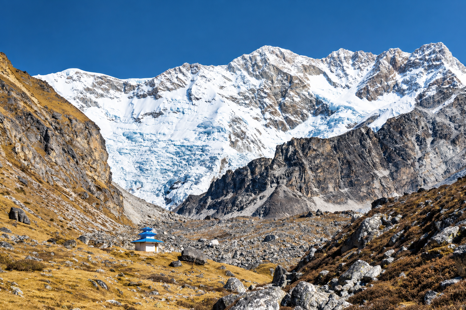
Kanchenjunga Base Camp
0 wishlisted0 done
Sign in to save this trek to your list.
Is This Trek for You?
Choose Kanchenjunga if remoteness, cultural depth, and a long expedition-style journey appeal more than convenience. You should be comfortable with basic accommodation, difficult access, high passes, limited rescue options, and three-plus weeks of commitment. This is for experienced trekkers with strong fitness, flexible schedules, and respect for changing mountain conditions.
Overview
Kanchenjunga is the eastern Himalaya at its most remote: a long trail of cardamom plantations, forested ridges, stone villages and glacial valleys leading to the foot of the world’s third-highest mountain. The journey is slow by design. Roads end early, the valleys are vast, and every gain in altitude changes the weather, vegetation and rhythm of the trek.
The full circuit visits both sides of the massif. To the north, the trail climbs the Kanchenjunga Glacier valley to Pang Pema (about 5,143m), where the mountain rises in a wall of ice and granite. To the south, the route crosses high passes and reaches Oktang (about 4,730m), a broad viewpoint above the Yalung Glacier. Between them lie difficult days, basic lodges, and some of Nepal’s least-visited trekking country.
This is not a trek for a hurried itinerary. The rewards are measured in distance: a morning mist lifting from a forest, a prayer flag snapping above a pass, the first clean view of Jannu, or the sudden appearance of Kanchenjunga beyond the moraine.
Route & Key Stops
Taplejung and the Lower Valleys
The approach usually begins with a flight to Bhadrapur followed by a long road journey towards Taplejung. From the trailhead, the route drops and climbs through humid foothills, cardamom fields and Limbu villages. The lower days are warm, green and deceptively strenuous; frequent ascents and descents make the first week good conditioning for the high country.
Sekathum and the Ghunsa Valley
Beyond Sekathum, the trail follows the Tamor and Ghunsa rivers through steep forest. Suspension bridges, waterfalls and narrow ledges keep the walking interesting. At Ghunsa (about 3,415m), wooden houses and Buddhist prayer flags signal a change in landscape and culture. Most itineraries use the village for an acclimatization day before climbing higher.
Khangpachen and Pang Pema
The valley narrows beyond Ghunsa as juniper, larch and birch give way to alpine scrub. Khangpachen is a useful staging point for the climb towards the north base camp. The final approach to Pang Pema follows rough glacial terrain, with the Kanchenjunga massif growing larger at every bend. Return to a lower camp after the viewpoint; sleeping at the highest point is not the aim.
Mirgin La and the Southern Valleys
The circuit turns south across a chain of high passes commonly grouped under the Mirgin La crossing. Weather can change quickly here, and snow may obscure the trail. Descend carefully into the broad Yalung Valley, where the landscape opens around the glaciers and the southern face of Kanchenjunga.
Oktang and the Yalung Glacier
From Ramche, a long day excursion leads towards Oktang, the South Base Camp viewpoint. The trail climbs over moraine and open mountain ground, with Jannu and the southern wall of Kanchenjunga dominating the skyline. It is a day for an early start, a warm layer, and patience with the altitude.
The Return
The return follows the southern approach through Tseram, then drops back into forest and village country. By the time you reach the road, the dense green foothills feel almost tropical. Allow time for the road journey out; the last stretch is part of the expedition rather than a simple transfer.
Itinerary
1Sekathum to Amjilosa
The first walking day follows the Ghunsa Khola through warm, humid forest. The trail crosses suspension bridges and climbs steadily beside waterfalls, with bamboo, cardamom and broad-leaved trees crowding the slopes. Take the first hours gently: the repeated short climbs and descents are more tiring than the distance suggests. Amjilosa is a small hillside settlement reached after a final sustained climb, with simple rooms and a quiet evening above the river.
2Amjilosa to Gyabla
Leave Amjilosa on a narrow trail above the river, climbing through dense bamboo and rhododendron. The forest begins to thin as the valley rises, and the sound of the water falls away below. Gyabla sits in a sheltered bowl with broad views towards the upper valley; arrive with time to dry damp layers and refill bottles before the colder days ahead.
3Gyabla to Ghunsa
The trail climbs through fir and rhododendron forest before dropping to the river and rising again towards Pholey. Mani walls and prayer flags become more common as the route enters the Tibetan-influenced upper valley. Ghunsa is the main settlement beyond the lower villages, with wooden houses, small lodges and a useful change of pace before the high country.
4Acclimatization in Ghunsa
Spend the day walking above Ghunsa rather than resting completely. A gradual climb towards the Lapsan La area gives the body useful exposure to altitude while keeping the overnight elevation unchanged. Return to the village for lunch, check equipment and speak with your guide about snow and pass conditions before moving higher.
5Ghunsa to Khangpachen
Leave the last substantial forest and follow the Ghunsa Khola through larch, juniper and open alpine slopes. Cross rough ground beneath the Jannu massif, with the river often far below and cliffs rising on either side. Khangpachen is exposed and basic; keep warm, eat well and avoid rushing the final climb into camp.
6Khangpachen to Lhonak
This is a serious high-altitude day. The path threads between moraine fans and unstable slopes as the valley widens towards the Kanchenjunga Glacier. Vegetation fades to low scrub, the wind strengthens, and every climb takes longer than expected. Keep your pace deliberately slow and watch for altitude symptoms after reaching Lhonak.
7Pang Pema viewpoint and return to Lhonak
Leave before sunrise for Pang Pema, carrying only what you need for the day. The route crosses stark moraine and glacial terrain, with Kanchenjunga and the surrounding ice walls gradually filling the horizon. Spend a short, unhurried time at the viewpoint, then return to Lhonak. Start early and follow your guide’s assessment of weather and trail conditions.
8Lhonak to Khangpachen
Retrace the glacial valley, taking care on loose moraine and polished rock. The descent is easier on the lungs but hard on tired knees, especially where the trail traverses exposed slopes above the river. By Khangpachen the air feels noticeably fuller and the evening is warmer.
9Khangpachen to Ghunsa
Continue down through larch and rhododendron forest, crossing the river on suspension bridges. Ghunsa is a welcome return to warmer rooms and more reliable meals. Use the afternoon to dry gear and review the next day’s high-pass route with your guide.
10Ghunsa to Sele Le
Climb through forest to Sele Le. The pass section begins here, and the day can be demanding in poor weather.
11Sele Le to Tseram via the Mirgin La passes
Cross the high passes towards the southern side of the massif. Keep the pace steady and follow your guide closely on snow or loose ground.
12Tseram to Ramche
Follow the Yalung Valley towards Ramche, with broad glacier views and a growing sense of remoteness.
13Oktang viewpoint and return to Ramche
Walk towards Oktang above the Yalung Glacier, then return to Ramche. Conditions may require a shorter viewpoint walk.
14Ramche to Tseram
Descend through the open valley and back into warmer air.
15Tseram to Yamphudin
Cross ridges and descend towards the southern villages. This is a long day on rough, varied trail.
16Yamphudin to Khebang
Leave the high country behind and return to forest, farms and settled valleys.
Route Map
Elevation Profile
Logistics & Support
Getting There and Back
The trek begins at Sekathum, not in Kathmandu or Taplejung. Most travellers fly from Kathmandu to Bhadrapur, then continue by road through the eastern hills to Taplejung and onward to Sekathum. The approach is long and road conditions can change, so allow a full buffer day when booking flights and international connections.
The walking itinerary ends at Khebang. From there, arrange a local road transfer back towards Taplejung and continue by road to Bhadrapur for the flight to Kathmandu. Your agency should confirm the current roadhead, vehicle availability and overnight stops shortly before departure.
Booking, Guides & Cash
Kanchenjunga is a restricted, remote trek. Book through a registered agency, travel with a licensed guide, and expect the itinerary to change with weather, landslides, snow and local access conditions. Lower-route teahouses may be comfortable; upper camps and lodges are functional rather than luxurious. Carry cash, a warm sleeping bag, and enough patience for slow transport.
Weather & Seasons
The best seasons are Autumn (October-November) and Spring (March-May).
| Season | Conditions |
|---|---|
| Autumn (Oct-Nov) | Post-monsoon clarity and the most reliable trail conditions; cold nights at Ghunsa and above, freezing at Lhonak and Pang Pema |
| Spring (Mar-May) | Warming temperatures, rhododendron blooms on the lower route, patchy snow lingering on the Sele Le passes |
| Winter (Dec-Feb) | Cold and clear at low elevations, but heavy snow can close the high camps and pass sections; agency itineraries often pause |
| Monsoon (Jun-Sep) | Heaviest rain in eastern Nepal — landslides on the access roads, leeches on the lower trail, obscured views; not recommended |
Weather drives this trek more than the calendar. Landslides, snow and river conditions regularly reshape daily plans between Ghunsa and the high camps; build flexibility into flights and permits rather than assuming the itinerary holds.
Tips
- Book through a registered agency. Kanchenjunga is a restricted-area trek: expect licensed-guide requirements, registered routes and logistics handled by your agency.
- Buffer the approach. The flight to Bhadrapur plus road journey to Sekathum is long and changeable — allow slack before international connections.
- Carry cash for the whole route. There are no reliable card facilities between Taplejung and Khebang; budget permits, meals and emergencies in cash.
- Let Ghunsa acclimatize you. Use the scheduled acclimatization day at Ghunsa (3,800m) before pushing towards Lhonak and Pang Pema.
- Treat the itinerary as a plan, not a promise. Weather, landslides and snow decide the high sections; expect reroutes and camp changes.
- Respect the mountain. Ask before photographing people, homes or monasteries, walk clockwise around mani walls and prayer wheels, and leave no trace in the high valleys.
Frequently Asked Questions
Planning
When is the best time to trek to Kanchenjunga Base Camp?
Spring (March-May) and autumn (September-November) offer the most reliable conditions. Spring brings rhododendron colour in the lower valleys; autumn usually brings crisp mountain visibility. The monsoon is wet and landslide-prone, while winter can close high passes and lodges.
How long does the trek take?
The walking itinerary shown takes 16 days from Sekathum to Khebang. Road transfers and flights to and from the trailheads are additional, and buffer days are wise because weather and trail conditions can disrupt the schedule.
Can I visit both base camps?
Yes. The full circuit reaches Pang Pema, the North Base Camp viewpoint at about 5,143m, then crosses the Mirgin La and related passes to Oktang, the South Base Camp viewpoint at about 4,730m. Some itineraries visit only the north or south side.
How do I reach the trailhead?
Most itineraries fly from Kathmandu to Bhadrapur and continue by road towards Taplejung or Sekathum. The road journey is long and conditions vary, so your agency should build flexibility into the approach and return.
Difficulty & Altitude
How difficult is the trek?
Extreme. This is a long, remote trek with demanding ascents, rough trail, limited facilities, and several days above 4,000m. Previous multi-day trekking experience and strong conditioning are important.
What is the highest point?
The highest destination is Pang Pema at about 5,143m. The route across the Mirgin La group also reaches above 4,500m, depending on the itinerary and pass conditions.
Do I need technical climbing skills?
No technical climbing is required on the standard trekking route, but snow, ice, steep scree, and route-finding can make the high passes serious. Your guide may change or omit a pass if conditions are unsafe.
What about altitude sickness?
The risk is significant once the route rises above 3,000m. Ascend gradually, include acclimatization days, drink regularly, and descend immediately if symptoms worsen or include confusion, breathlessness at rest, or loss of coordination.
Permits & Costs
What permits do I need?
You need a Kanchenjunga Restricted Area Permit, a Kanchenjunga Conservation Area entry permit, and the agency-issued TIMS card required for the Kanchenjunga Base Camp route. A registered trekking agency arranges the restricted permit and guide.
What is the current restricted-area permit fee?
The Department of Immigration currently lists Taplejung restricted-area permits at USD 20 per person per week for the first four weeks and USD 25 per week beyond that. Confirm the current calculation and covered wards with your agency before departure.
Is a guide required?
Yes. Nepal Tourism Board lists the Kanchenjunga Base Camp route among those requiring a licensed guide and an agency-issued TIMS card. Independent solo trekking is not permitted on this route.
Route & Accommodation
What is accommodation like?
Lower sections use simple teahouses and homestays. Higher sections have basic lodges or organised camping, with shared rooms, limited heating, and fewer food choices. Bring a warm sleeping bag and expect facilities to become increasingly basic.
Is the trail crowded?
Compared with Everest and Annapurna, Kanchenjunga is quiet and remote. You will still meet other groups in peak season, but long stretches of trail can feel solitary.
What wildlife might I see?
The conservation area protects a wide range of eastern Himalayan habitat. Birdlife is common; sightings of larger wildlife such as red panda are possible but never guaranteed. Travel quietly and follow your guide's advice around wildlife.
Highlights
What makes Kanchenjunga special?
The trek links distinct landscapes and cultures: cardamom-growing foothills, Limbu and Rai villages, dense rhododendron forests, glacial valleys, and huge mountain walls. The scale increases slowly, which makes the arrival beneath Kanchenjunga feel earned.
What is Pang Pema?
Pang Pema is the North Base Camp viewpoint, reached up the Kanchenjunga Glacier valley. From the viewpoint, the mountain and surrounding peaks fill the horizon across a stark high-altitude landscape.