Manaslu Circuit
0 wishlisted0 done
Sign in to save this trek to your list.
Is This Trek for You?
Choose Manaslu if you want a quieter, restricted-area route with Tibetan-influenced villages and a demanding high-pass crossing. It suits experienced trekkers who accept basic facilities, agency logistics, and long days above 4,000m. It is not ideal for a first trek unless you are very well prepared and accompanied by a strong guide team.
Overview
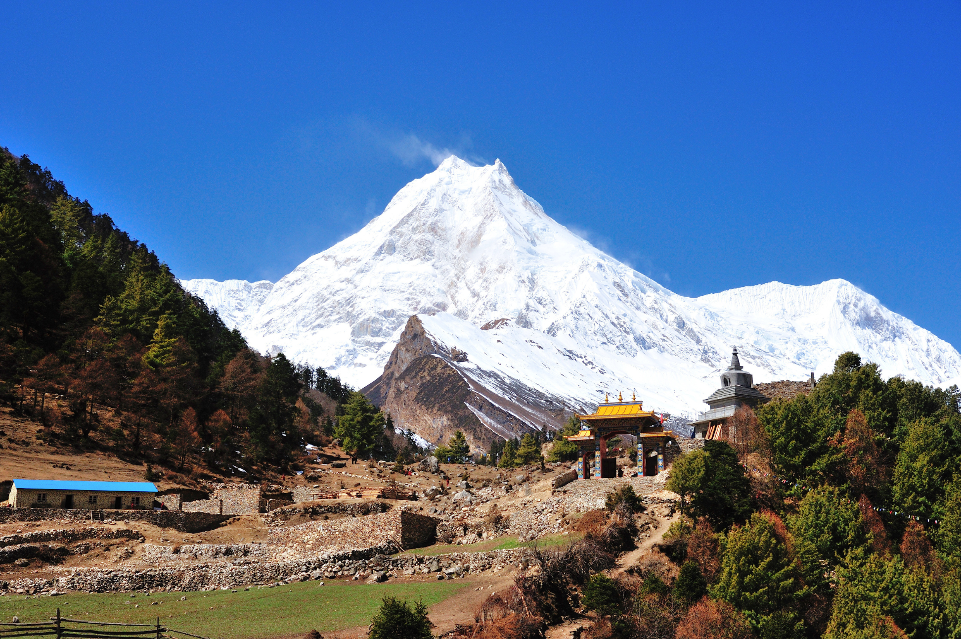
The Manaslu Circuit is what the Annapurna Circuit was 30 years ago — remote, uncrowded, and breathtakingly diverse. This restricted-area trek circles Mount Manaslu (8,163m), the world’s eighth-highest peak, crossing the formidable Larkya La pass at 5,106m. It’s widely regarded as one of the finest long-distance treks in the Himalayas.
Because it’s a restricted area, fewer than 10,000 trekkers complete this route annually (compared to 60,000+ on the Annapurna Circuit). You’ll walk through Tibetan-influenced villages, past ancient monasteries, and across landscapes that shift from subtropical forest to high-altitude desert. The trail follows the Budhi Gandaki river through some of the deepest gorges in Nepal before climbing to the dramatic Larkya La pass.
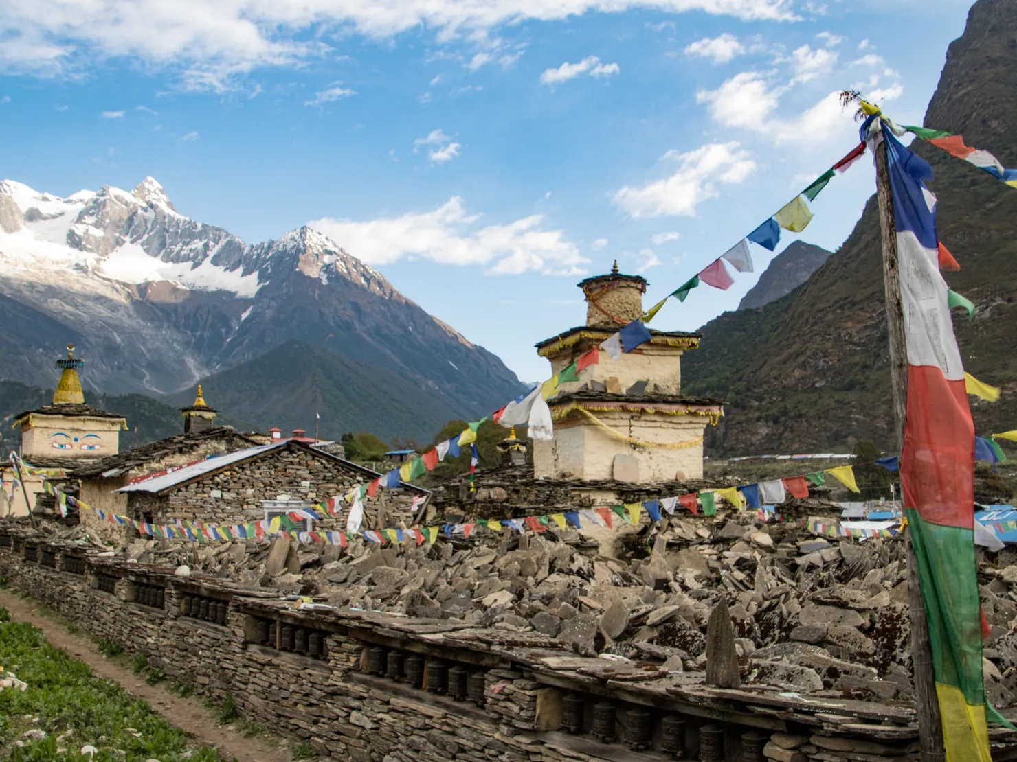
The cultural richness is extraordinary. The upper valley is virtually Tibetan — prayer wheels line the trails, mani walls stretch for hundreds of meters, and ancient gompas sit perched on ridges. Samagaon and Samdo are base camps for Manaslu climbing expeditions, and the local Nubri and Tsum communities maintain traditions that have remained largely unchanged for centuries.
Route & Key Stops
Soti Khola & Machha Khola: The Starting Point
The trek begins at Soti Khola (700m) or Machha Khola (870m), accessible from Kathmandu by bus or jeep (8-9 hours). The trail follows the Budhi Gandaki river through subtropical farmland and Gurung villages. The river gorge begins to narrow with waterfalls and hot springs along the way. This lower section feels distinctly Nepali, with Hindu shrines, rice paddies, and subtropical jungle alive with birdsong. The air is thick and warm, a world apart from the high-altitude desert you’ll reach in a matter of days.
Jagat: Gateway to the Restricted Area
Jagat (1,340m) is the entry point to the restricted area, where your permits will be checked at the checkpoint. Beyond Jagat, the trail continues through increasingly dramatic gorges with towering cliffs on both sides, the river roaring far below. Cross suspension bridges and pass through Khorlabesi and Tatopani (natural hot springs), where you can soak tired legs in the geothermally heated pools. The landscape is still lush and tropical, but the mountains are growing taller with every step.
Deng: The Cultural Shift
Deng (1,804m) marks the transition into Tibetan Buddhist territory, and the change is striking. The valley narrows dramatically, and within hours of leaving Jagat you’ll notice the cultural shift: Hindu shrines give way to prayer wheels and mani walls, the architecture becomes distinctly Tibetan with flat-roofed stone houses, and the language shifts from Nepali to Nubri, a Tibetan dialect. Deng itself is a small, remote village that feels a world away from Kathmandu. This is where the Manaslu Circuit begins to reveal its true character, a corridor between two vastly different cultural worlds.
Namrung & Lho: Into Nubri
Namrung (2,630m) has a gompa with views of Manaslu North. Lho (3,180m) offers your first dramatic views of Manaslu itself — the massive peak dominates the skyline. The monastery in Lho is worth visiting, and the village marks the entrance to the Nubri region, which is virtually all Tibetan in origin.
Samagaon: The Acclimatization Hub
Samagaon (3,530m) is one of the largest villages on the circuit and the base for Manaslu climbing expeditions. From the village, the sheer north face of Manaslu towers above the valley, its ice-glazed summit often wreathed in cloud. On a clear morning, the mountain fills your entire field of vision, an overwhelming reminder of where you are. Visit Birendra Tal, a glacial lake reflecting the surrounding peaks, and explore the local monastery where monks chant beneath Thangka paintings. More adventurous trekkers can hike toward Manaslu Base Camp (4,800m) for an up-close look at the glacier. Samagaon is your critical acclimatization stop, spend at least one full day here, hiking high and sleeping low.
Samdo: The Last Village
Samdo (3,860m) is the last permanent settlement before the pass, and it has the feel of a frontier outpost. The valley opens into a wide glacial basin surrounded by towering peaks, with yak pastures stretching along the river. The local Nubri people are ethnically Tibetan, and you’ll see them tending yaks and trading goods that have moved across the border for generations. Hike toward the Tibetan border at Rui La (4,998m) for acclimatization and stunning views into Tibet, or simply rest and soak in the thin mountain air.
Dharamsala: The Launchpad
From Samdo, the trail to Dharamsala (4,460m) is short but relentless, climbing steeply through scrubland and moraine. The landscape is barren and lunar, with nothing but rock, ice, and the occasional hardy flower. Dharamsala is a basic stone shelter at the foot of Larkya La, cold and windswept, but the anticipation of tomorrow’s crossing makes it one of the most exciting nights of the trek. Sleep early, hydrate well, and prepare for the biggest day of the circuit.
Larkya La: The High Point
Larkya La (5,106m) is the highest point of the trek and one of the most dramatic pass crossings in Nepal. The climb starts before dawn from Dharamsala, typically around 4 or 5am, with headlamps cutting through the darkness. The ascent is steep, climbing through loose scree, snow, and rock as the sky slowly lightens. Reaching the pass as the sun crests the ridgeline is a genuinely emotional moment: prayer flags snap in the wind, and the panorama unfolds in every direction, Manaslu to the east, Himlung Himal to the north, Cheo Himal and the Annapurna range to the south. The pass feels raw and exposed, a true high-mountain experience that rewards every ounce of effort.
Bimthang & Dharapani: The Descent
The descent from Larkya La drops sharply through alpine meadows and moraine fields before entering dense rhododendron and bamboo forest. The bamboo groves are thick and cathedral-like, their tall stalks creaking in the breeze, a dramatic contrast to the barren moonscape you crossed just hours ago. The trail eventually reaches Bimthang (3,720m), a beautiful alpine meadow with stunning views back toward Manaslu and the pass. From Bimthang, the trail continues down the Marsyangdi valley through increasingly lush forest to Dharapani (1,980m), where it connects with the Annapurna Circuit route. The lower valley returns you to Hindu-influenced villages, completing the cultural arc of the trek. From Dharapani, a jeep or bus takes you back to Kathmandu.
Highlights
Manaslu Summit Views
Mount Manaslu (8,163m) is the crown of the trek. The mountain’s name derives from the Sanskrit word “Manasa,” meaning intellect or soul, and the Nubri people regard it as a sacred peak. From Samagaon, the north face rises over 3,000 meters above the valley floor, a wall of ice and rock that is both humbling and awe-inspiring. On the Larkya La crossing, you’ll see the mountain from an entirely different angle, its massive bulk dominating the eastern horizon with surrounding peaks like Ngadi Chuli and Himalchuli completing the panorama.
Ancient Monasteries
The Manaslu region is dotted with monasteries that date back centuries. The gompa in Lho houses a revered statue of Padmasambhava and ancient thangka paintings. In Samagaon, the local monastery hosts festivals with masked dances during the Manaslu expedition season. Further up the valley, smaller shrines and chortens appear at nearly every turn, each one marking a spiritual boundary or commemorating a historical event. The Nubri and Tsum communities maintain these monasteries as living centers of Tibetan Buddhist practice, not as tourist attractions.
Glacier Hiking
From Samagaon, a half-day hike toward Manaslu Base Camp (4,800m) brings you onto the lateral moraine of the Manaslu Glacier. The terrain is raw and prehistoric, with glacial till, ice formations, and the occasional yak wandering across the frozen landscape. You don’t need crampons or technical gear for the approach, but sturdy boots and a good level of fitness are essential. The glacier itself is retreating, making this a landscape that is literally changing before your eyes.
Wildlife
The Manaslu Conservation Area is home to an impressive range of Himalayan fauna. Himalayan tahr are commonly spotted on the rocky slopes above Samagaon, while blue sheep (bharal) graze on the high-altitude grasslands near Larkya La. The elusive snow leopard prowls these same ridgelines, though sightings are extraordinarily rare. Lower down, watch for ghoral (Himalayan goats), musk deer in the bamboo forests, and a stunning variety of birds including the colorful Impeyan pheasant (Nepal’s national bird) and lammergeier vultures soaring above the gorges.
Itinerary
1Soti Khola to Machha Khola
Walk through subtropical forest along the Budhi Gandaki river gorge. The trail passes through Gurung villages and terraced farmland. The river gorge begins to narrow with waterfalls and hot springs along the way.
2Machha Khola to Jagat
Continue along the Budhi Gandaki through increasingly dramatic gorges. Cross suspension bridges and pass through Khorlabesi and Tatopani (hot springs). Jagat is the entry point to the restricted area.
3Jagat to Deng
Enter the restricted area. The valley narrows dramatically with towering cliffs on both sides. Cross to the west bank of the Budhi Gandaki. Deng is a small Tibetan-influenced village — the cultural shift is immediate.
4Deng to Namrung
Climb through pine forests into Tibetan Buddhist territory. Prayer wheels and mani walls appear. Namrung has a gompa with views of Manaslu North. The landscape becomes increasingly arid and Tibetan.
5Namrung to Samagaon
Continue through Lho (with its monastery and Manaslu views) to Samagaon (3,530m). Visit the Birendra Tal lake and monastery. Samagaon is the base for Manaslu climbing expeditions and your first major acclimatization stop.
6Acclimatization in Samagaon
Essential rest day. Hike to Manaslu Base Camp viewpoint or explore the Birendra Tal and surrounding glaciers. Visit the local monastery and acclimatize properly before the Larkya La approach.
7Samagaon to Samdo
Walk along the Budhi Gandaki to Samdo, the last village before the pass. The valley opens into a wide glacial basin. Acclimatize with a day hike toward the Tibetan border and the Larkya glacier.
8Samdo to Dharamsala (Larkya BC)
Short but steep climb to Dharamsala (Larkya Base Camp) at 4,460m. The trail passes through scrubland with views of Larkya La ahead. Rest well — tomorrow is the biggest day.
9Larkya La Pass Crossing
The big day. Start early for the steep climb to Larkya La (5,106m). Prayer flags mark the pass with incredible views of Manaslu, Himlung Himal, and Cheo Himal. Long descent to Bimthang through alpine meadows and moraine.
10Bimthang to Tilije
Descend through alpine meadows and rhododendron forest. Cross the Budhi Gandaki on a high trail with views of Manaslu and the surrounding peaks. Pass through Karche and arrive at Tilije on the Marsyangdi river.
11Tilije to Dharapani
Continue descent through the Marsyangdi valley. The trail connects with the Annapurna Circuit route at Dharapani (2,130m). The lower altitude and warmer temperatures feel wonderful after days above 4,000m.
Alternative Itinerary
The itinerary shown has 11 days on foot. Add trekking days for further acclimatization or the Rui La side trip; combining Manaslu with the Tsum Valley adds several more route days. Road transfers to Soti Khola and from Dharapani are separate. See our other trek guides to compare alternatives.
Route Map
Elevation Profile
Logistics & Support
Getting There and Back
Getting to the trailhead: Travel by bus or jeep from Kathmandu to Soti Khola, usually an 8-9-hour road journey in the itinerary described here. Road access can change; confirm the exact starting point, transfer time and overnight plan with your operator.
Returning from the trail: The walking route ends in Dharapani. Arrange road transport from there to Kathmandu; the journey is long and can be affected by road conditions, so allow a buffer.
Accommodation
Teahouses line the entire route. They’re simple but cozy — locally run, with warm dining rooms and basic twin bedrooms. The higher you go, the more basic the facilities become. Hot showers and Wi-Fi are available in lower villages but disappear above 3,500m. Bring a good sleeping bag — rooms have no heating.
Guides & Porters
Trekking with a licensed guide through a registered agency is required for this restricted route. Group-size and permit eligibility rules can change; confirm them with the agency before booking. Porter availability and load arrangements vary by agency.
Permits
The main permits and route requirements are:
- Restricted Area Permit: during September-November, USD 100 per person for the first week plus USD 15 per additional day; during December-August, USD 75 per person for the first week plus USD 10 per additional day, under the current Department of Immigration schedule.
- Manaslu Conservation Area entry permit: NPR 3,000 for foreign visitors under the current Nepal Tourism Board fee table.
- Annapurna Conservation Area entry permit: NPR 3,000 for foreign visitors under the current NTB table; required for the standard exit via Dharapani.
- Guide and agency-issued TIMS: NTB lists the Manaslu Circuit among routes requiring a licensed guide and agency-issued TIMS; confirm the applicable TIMS fee with your agency.
These are arranged through a registered trekking agency. Restricted-area eligibility and group requirements can change, so ask the agency to confirm the current rules before booking.
High-altitude trekking and rescue insurance is strongly recommended. Check coverage for the elevations on your itinerary, emergency evacuation, and altitude-related illness; verify exclusions directly with your insurer.
Budget
| Item | Cost |
|---|---|
| Permits | ~$180 |
| Guide | $30-50/day |
| Teahouse room | $5-10/night |
| Meals | $4-8/meal |
| Kathmandu-Soti Khola transport | $15-25 |
| Daily budget | $35-65/day |
Weather & Seasons
The best seasons are Spring (March-May) and Autumn (September-October).
| Season | Conditions |
|---|---|
| Spring (Mar-May) | Warming temperatures, rhododendrons in bloom, some haze, possible snow on Larkya La |
| Autumn (Sep-Nov) | Stable, dry weather with crystal-clear mountain views — peak season |
| Winter (Dec-Feb) | Extremely cold, heavy snow blocks Larkya La, trails impassable |
| Monsoon (Jun-Aug) | Heavy rain, landslides, dangerous trail conditions |
Autumn offers the clearest skies and most reliable weather for the pass crossing. Spring is warmer but hazier and may have more snow on Larkya La. One thing worth noting: the Manaslu region sits in a partial rain shadow, meaning it receives significantly less rainfall during monsoon than nearby Annapurna. That said, the trails are still muddy and landslide-prone, and the pass is often socked in, so monsoon treks remain inadvisable. Winter and monsoon treks are not recommended, the pass becomes treacherous.
Tips
- Acclimatize properly. Larkya La is the highest point and demands good acclimatization. Spend at least one full day in Samagaon, hiking up to 4,000m and returning to sleep at 3,530m.
- Start the pass crossing early. Weather deteriorates by midday. Leave Dharamsala at 4-5am with a headlamp and plenty of water.
- Book through an agency. Restricted area regulations require licensed operators and a minimum of 2 trekkers. Book well in advance during peak autumn season, as permits and agency slots fill up quickly.
- Arrange permits early. The restricted area permit takes 3-5 working days to process and must be arranged through a registered trekking agency in Kathmandu. Don’t leave this to the last minute, especially during peak season when processing can take longer.
- Carry enough cash. There are no ATMs on the route and credit cards are not accepted above Jagat. Budget $25-35 per day for food and drinks, and carry enough Nepali rupees for the entire trek. Fees for teahouses increase with altitude.
- Pack light. Tea houses provide bedding and meals, so you don’t need camping gear. A 35-45L daypack is sufficient if you have porters.
- Respect the culture. Remove shoes before entering monasteries, walk clockwise around chortens and mani walls, and ask permission before photographing locals or religious sites.
- Hit the best viewpoints. The ridge above Lho offers a classic Manaslu framing with the monastery below. The trail between Samagaon and Samdo has a stunning viewpoint where the entire Budhi Gandaki valley opens up. And of course, Larkya La itself is the ultimate panorama, arrive early to enjoy it in golden morning light before the clouds roll in.
- Consider the Tsum Valley extension. This adds 4-5 days through remote Buddhist monasteries and is well worth the time.
Frequently Asked Questions
Planning
When is the best time to go?
The best seasons are Spring (March-May) and Autumn (September-November). Autumn is generally preferred for clearer skies. The trail can be muddy during monsoon season and snowy in winter.
How many days do I need?
The itinerary shown has 11 days on foot, including an acclimatization day in Samagaon. Allow additional time for a slower pace, extra rest and the road journeys to Soti Khola and from Dharapani.
Can I do this trek independently?
No. The Manaslu Circuit is a restricted route covered by Nepal's guide and agency-issued TIMS requirements. It requires an organized itinerary with a licensed guide through a registered trekking agency.
Do I need to bring cash?
Yes. There are no ATMs on the route and credit cards are not accepted. Bring enough Nepali rupees for the entire trek. Budget around $25-35 per day for meals and incidentals.
Difficulty & Altitude
How hard is the trek?
Challenging. The Manaslu Circuit is considered one of Nepal's most demanding treks. The terrain varies from subtropical forests to high-altitude barren landscapes. Larkya La at 5,106m is the crux of the trek.
What about altitude sickness?
The itinerary includes acclimatization days. Ascend gradually, stay hydrated, and don't push through symptoms. The high point at Larkya La (5,106m) requires good acclimatization.
Do I need technical climbing skills?
No technical skills are required. The trails are well-established. The pass crossing can be icy in early season, but your guide will provide basic instruction. Good fitness is essential.
Permits & Costs
What permits do I need?
You need the Manaslu Restricted Area Permit, Manaslu and Annapurna conservation-area entry permits on the standard Dharapani exit, and the guide and agency-issued TIMS required under current Nepal Tourism Board guidance. A registered trekking agency arranges the restricted permit.
How much does it cost?
Budget depends on season, itinerary, transport, and group size. The restricted-area permit is charged by week plus additional days under the current seasonal schedule, alongside conservation-area permits and guide costs. Request an itemized quote from a registered agency.
Route & Navigation
Is a guide required?
Yes. Nepal Tourism Board lists Manaslu Circuit among routes requiring a licensed guide and agency-issued TIMS. Your registered agency arranges the restricted permit and guide.
What is the accommodation like?
Basic teahouses line the entire route. Rooms are simple with twin beds and blankets. Facilities decrease as you gain altitude. Bring a sleeping bag rated to -10°C.
Is the trail crowded?
No. The Manaslu Circuit is significantly less crowded than the Everest and Annapurna regions. You'll often have teahouses to yourself, especially in the upper reaches.
Best Views & Highlights
What makes Manaslu special?
The Manaslu Circuit combines high mountain scenery, Buddhist monasteries, and village life in the Budhi Gandaki valley. The route crosses Larkya La at 5,106m and passes through communities with strong cultural ties to Tibet.
What will I see from Larkya La?
From the pass, you'll see Manaslu (8,163m), Himalchuli (7,893m), and the Annapurna range to the south. The panoramic views are among the best in Nepal.