Upper Mustang
0 wishlisted0 done
Sign in to save this trek to your list.
Is This Trek for You?
Choose Upper Mustang if ancient villages, monasteries, desert landscapes, and Tibetan culture interest you more than lush forests or snowbound passes. It suits travelers comfortable with high costs, basic facilities, dust, wind, and restricted-area logistics. It is a cultural journey as much as a mountain trek, and a guide is essential.
Overview
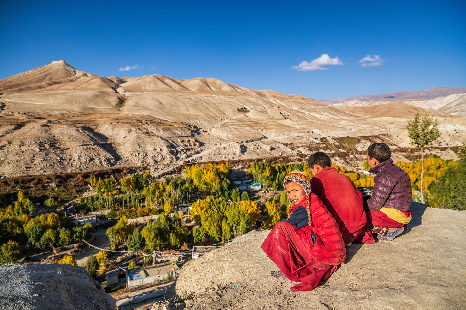
Upper Mustang was closed to foreigners until 1992, and even today remains one of the most restricted and preserved regions in Nepal. This is not a typical mountain trek. It’s a journey into a high-altitude desert landscape that feels more like Tibet than Nepal. There are no lush rhododendron forests, no terraced rice paddies, no green valleys here. Instead, you walk through a world of eroded sandstone, wind-carved canyons, and vast, silent plateaus under an impossibly blue sky.
The trail follows the historic salt-trade route from Kagbeni to Lo Manthang, the walled capital of the former Kingdom of Lo. Along the way, you’ll pass through villages with flat-roofed houses, visit ancient cave monasteries, and witness a landscape sculpted by wind and water into dramatic canyons and pillars. Mustang’s communities preserve strong Tibetan cultural and Buddhist traditions.
Upper Mustang lies in the rain shadow of the Annapurna and Dhaulagiri ranges, making it trekable when the rest of Nepal is in monsoon. The terrain is stark and beautiful with deep reds, oranges, and grays of wind-eroded cliffs, and snow-capped peaks on the horizon. The culture is purely Tibetan Buddhist, with monasteries, mani walls, and prayer flags dominating the landscape. This is one of the most culturally rich treks in Nepal.
Route & Key Stops
Pokhara & Jomsom: The Gateway
The trek begins in Pokhara (820m), Nepal’s lakeside city and a useful base for final preparations. From Pokhara, take an early flight to Jomsom (about 2,720m), weather permitting. The route follows the Kali Gandaki valley between the Annapurna and Dhaulagiri ranges. Flights can be delayed or cancelled by weather, and winds often strengthen later in the day. Jomsom has markets, guesthouses and services; ask locally what supplies are available before continuing north.
Kagbeni: The Medieval Gateway
Kagbeni (2,810m) is the medieval walled town and official gateway to Upper Mustang, where the last traces of green Himalayan foothills give way to the stark beauty of the desert kingdom beyond.
Walk from Jomsom along the Kali Gandaki riverbed (10km, 2-3 hours), a wide expanse of gray sand and braided streams flanked by towering canyon walls. The trail is dusty and windy, a preview of the arid landscape ahead. Kagbeni sits at the confluence of the Jhong Khola and Kali Gandaki rivers, a tangle of narrow stone alleyways, flat-roofed houses, and apple orchards shaded by poplar trees. A red monastery with prayer wheels turns slowly on the hill above town.
Your restricted area permit is checked here at the police post, marking the boundary between open Nepal and the forbidden kingdom. Wander the ancient alleyways, peer into the 15th-century Kagbeni monastery, and watch the sunset paint the surrounding cliffs in shades of amber and rust. This is the last outpost of normalcy before you cross into another world.
Chele: The Desert Begins
From Kagbeni, enter the restricted area and climb from the Kali Gandaki to Chele (3,050m) through dramatic red rock formations and wind-eroded canyons that feel more like the American Southwest than Nepal. The transformation is immediate and striking.
Within an hour of leaving Kagbeni, the last green fields and poplar groves vanish, replaced by a moonscape of eroded pillars, layered sandstone cliffs in deep crimson and burnt orange, and vast expanses of gravel and dust. The trail rises steadily through a narrow defile, climbing past wind-carved formations that resemble melted candle wax and ancient fortress walls. Eagles and choughs ride the thermals above the canyon rim.
Chele is a small cluster of stone teahouses huddled beneath a cliff face, the first true settlement in Upper Mustang. The silence here is profound, broken only by the wind whistling through the canyons.
Syangboche: The High Passes
Cross two passes: Chele La (3,810m) and Samar La (3,620m), with stunning views of Nilgiri, Tilicho, and Annapurna. The trail passes through ancient cave settlements and open valleys with gradual altitude gain, winding between eroded ridges of red and gray. Syangboche (3,750m) sits in a sheltered valley with views of the surrounding desert landscape, a cluster of stone houses and a small monastery. The route crosses several small ridges around 3,600 meters before descending into the village. This is a good place to acclimatize, with relatively gentle terrain and clear mountain views on clear days.
Ghami: The Ancient Village
Ghami (3,520m) is one of the largest settlements in Upper Mustang, a living testament to centuries of Tibetan Buddhist culture preserved in this remote desert valley. Whitewashed homes with flat roofs and prayer flags fluttering from wooden poles line the narrow lanes, their stone walls unchanged by modern life. The village monastery, perched on a rocky outcrop above the houses, is a fortified structure with thick walls, prayer wheels along the perimeter, and a courtyard where monks perform daily rituals. Step inside to find dimly lit prayer halls with butter lamps flickering before ancient statues, the air heavy with incense. Walk through the longest mani wall in Nepal, a sacred Buddhist monument stretching across the valley, built from thousands of inscribed stones bearing the mantra “Om Mani Padme Hum.” Locals add stones to the mani wall continually, maintaining traditions centuries old, always passing it on the left as a mark of respect.
Tsarang: The Second Capital
Descend through the dramatic Tsarang gorge, where the trail threads between towering red and ochre cliffs, to Tsarang (3,560m), the ancient capital and second largest settlement in Upper Mustang. Tsarang was once the seat of power before Lo Manthang rose to prominence, and the village retains a quiet grandeur. Visit the Tsarang dzong (fortress), a crumbling but imposing structure that once housed the regional governor, and the 15th-century red monastery with remarkable murals of protective deities and celestial landscapes. The monastery courtyard offers sweeping views of the deep canyon below. Tsarang sits at the junction of the classic and eastern routes, and the village has a royal palace and a library with ancient Tibetan manuscripts stacked on wooden shelves. Spend a moment in the dzong’s courtyard, where the silence and the scale of the surrounding cliffs make you feel very small.
Lo Manthang: The Walled Capital
Lo Manthang (3,840m) is the 600-year-old capital of the Kingdom of Lo, a semi-autonomous, heavily Tibetan-influenced city where time seems suspended in the high desert. Cross the Lo La pass for your first view of the walled capital, a dramatic sight of whitewashed walls and flat-roofed buildings rising from the ochre plateau, framed by barren mountains and an endless sky.
The city is enclosed by ancient mud-brick walls, their surfaces smoothed by centuries of wind. Step through the gates into narrow alleys where monks in maroon robes shuffle between monasteries, women carry water in wooden yokes, and the sound of prayer wheels turning fills the air. Explore the royal palace, a four-story structure of whitewashed mud and timber that dominates the skyline.
Visit Champa Lhakhang (15th century), with its exquisite ceiling paintings of mandalas and celestial beings, and Thubchen Gompa, the great monastery with remarkable murals depicting the life of the Buddha in vivid blues, reds, and golds. The Jampa gompa, a chapel of skulls and thangka paintings, houses ancient manuscripts. Outside the walls, explore the ancient sky caves and cave monasteries carved into the cliff faces, some dating back over 1,000 years. Lo Manthang is not a museum but a living, breathing capital, and its people guard their traditions with quiet pride.
Dhakmar: The Return
On the return, take the western route through Dhakmar (3,820m), a landscape of striking red cliffs and ancient chortens that feels like entering a painting. The name means “red cliffs,” and the name delivers: enormous walls of deep crimson sandstone rise on either side of the trail, streaked with veins of white and ochre. The route crosses three passes over 4,000m with sweeping views of the Annapurna range. Dhakmar has a small settlement and the Ghar Ghompa monastery, perched on a red cliff with centuries-old murals depicting the founding legends of Upper Mustang. The monastery is smaller and less visited than those in Lo Manthang, which makes it feel all the more special. This western return route offers a different perspective from the outbound journey, with new canyon formations and valleys that you didn’t see on the way in.
Highlights
The Caves of Upper Mustang
Cliffside caves appear throughout the Mustang landscape, their openings cut into bands of pale and rust-red rock. Cave complexes around the region have served different purposes over many centuries, but access, preservation, and interpretation vary by site. Ask your local guide which caves can be visited responsibly; do not enter or touch fragile archaeological features without permission.
Thubchen Gompa and Champa Lhakhang
The two most important monasteries in Lo Manthang sit within the walled city and are masterpieces of Tibetan Buddhist art. Thubchen Gompa, built in the 15th century, houses a prayer hall with remarkable wall murals painted in mineral pigments that retain their vivid blues, reds, and golds after five centuries. The murals depict tantric deities, celestial Buddhas, and scenes from the Jataka tales in extraordinary detail. Champa Lhakhang, even older, features a magnificent ceiling painting of the cosmic mandala and intricate woodcarvings on the pillars and window frames. Both monasteries are active places of worship, so visit respectfully during non-prayer hours. Your guide can arrange access and provide context for the iconography.
Itinerary
1Jomsom to Kagbeni
Walk along the Kali Gandaki riverbed to Kagbeni (2,810m), the medieval walled town and gateway to Upper Mustang. Explore the ancient alleyways and the red-walled Kagbeni monastery. Your restricted area permit is checked here.
2Kagbeni to Chele
Enter the restricted area. Climb from the Kali Gandaki to Chele (3,050m) through dramatic red rock formations and wind-eroded canyons. The landscape is stark and otherworldly with deep reds, oranges, and grays.
3Chele to Syangboche
Cross two passes (Chele La and Samar La) with stunning views of Nilgiri, Tilicho, and Annapurna. Descend to the remote village of Syangboche in a sheltered valley. The trail passes through ancient cave settlements.
4Syangboche to Ghami
Walk beside the celebrated mani wall at Ghami, a sacred Buddhist monument built from inscribed stones. Arrive at Ghami (3,520m), a historic village with a fortified monastery and traditional flat-roofed houses.
5Ghami to Tsarang
Descend through the dramatic Tsarang gorge to the ancient capital of the second largest settlement in Upper Mustang. Visit the Tsarang dzong (fortress) and the 15th-century red monastery.
6Tsarang to Lo Manthang
The final approach to Lo Manthang. Cross the Lo La pass for your first view of the walled capital, a dramatic sight in the desert landscape. Descend to the gates of Lo Manthang, the 600-year-old capital of the Kingdom of Lo.
7Lo Manthang
Full day exploring the capital. Visit Champa Lhakhang (15th century), Thubchen Gompa with its remarkable murals, the king’s palace, and the Jampa gompa. Explore the cave monasteries and ancient sky caves outside the walls.
8Lo Manthang to Dhakmar
Begin the return via the western route. Head west through three passes over 4,000m with views of the Annapurna range. Descend to Dhakmar (3,820m) with its dramatic red cliffs and ancient chortens.
9Dhakmar to Syangboche
Continue descent through the desert landscape back to Syangboche. The trail offers a different perspective from the outbound journey as familiar landmarks seen in new light.
10Syangboche to Chhusang
Descend through the Kali Gandaki gorge to Chhusang (2,980m), with towering cliffs and wind-sculpted rock along the route. Rejoin the main Kali Gandaki trail.
11Chhusang to Jomsom
Continue along the riverbed back to Jomsom. The lower altitude and warmer air feel wonderful after days in the desert. This is our final night in Jomsom. Celebrate completing Upper Mustang.
Alternative Itineraries
The standard walking itinerary takes about 11 days from Jomsom, but the route is flexible:
- Eastern route extension (+2-3 days): On the return, take the eastern route through Yara and Tangge for a longer loop. Ask a local guide about visiting the Luri cave monastery and other cultural sites along this route.
- Muktinath detour (+1 day): From Chhusang, cross the Gyu La pass to visit Muktinath Temple, a sacred pilgrimage site for both Hindus and Buddhists at 3,710m. For the longer west-to-east route, compare this with our Annapurna Circuit guide; confirm trail connections and transport locally.
- Shorter itinerary (10-11 days): Use a jeep from Kagbeni to Lo Manthang (one way) to reduce walking days. Pure walking versions take 12-14 days; jeep-assisted versions can be done in 10.
- Tiji Festival (May): Time your trek to coincide with the annual Tiji Festival in Lo Manthang, three days of masked dances, religious ceremonies, and celebrations. Book permits well in advance.
Route Map
Elevation Profile
Logistics & Support
Accommodation
Teahouses in Upper Mustang are basic but functional. They usually have twin-bed rooms with communal dining areas warmed by wood stoves. Food is available but limited and expensive due to remoteness. Lo Manthang has slightly better options. Some upper villages may require camping if teahouses are full, especially during festivals. Expect to pay more than other treks. The prices are inflated due to the restricted area and remote location. Dal bhat (rice, lentils, and vegetables) remains the best value meal, and most lodges serve it daily.
Guides & Porters
A licensed guide is mandatory. Upper Mustang is a restricted area. The guide arranges permits, handles logistics, and provides cultural context. Porters are recommended for carrying your main bag. Guides and porters are typically from the Mustang region themselves, offering authentic cultural insight and language skills that open doors to local homes and monasteries. Mobile signal disappears after Kagbeni, your guide carries paper maps as backup. Tips of 10-15% of the guide’s fee are customary at the end of the trek.
Permits
The key permits are:
- Restricted Area Permit: currently listed by Nepal’s Department of Immigration at USD 50 per person per day; confirm the total, minimum duration, and extension rules with your registered agency.
- Annapurna Conservation Area entry permit: NPR 3,000 for foreign visitors under the current Nepal Tourism Board fee table.
- Agency-issued TIMS card: Upper Mustang is listed by Nepal Tourism Board among routes requiring agency-issued TIMS. Confirm the current fee and how it is issued with your registered agency.
Restricted-area permit and group conditions can change; your registered agency should confirm current eligibility and paperwork before booking. The permit is checked at the route entry point and along the journey.
Budget
| Item | Cost |
|---|---|
| Restricted Area Permit | USD 50 per person per day under current Department of Immigration guidance; total depends on permit duration |
| Guide | $35-50/day |
| Teahouse room | $10-25/night |
| Meals | $8-15/meal |
| Pokhara-Jomsom flight | $120-150 (one way) |
| Daily budget | $60-100/day |
Upper Mustang is one of Nepal’s most expensive treks due to the permit cost and remote-location price inflation. Budget accordingly.
Getting There and Back
Getting to the trailhead: Travel from Pokhara to Jomsom by early flight or by road. Flights are weather-dependent; the jeep journey is long and road conditions vary. Start the walking itinerary in Jomsom.
Returning from the trail: The walk ends in Jomsom. Return to Pokhara by air or road, allowing buffer time for weather delays before onward connections.
Weather & Seasons
Upper Mustang lies in the rain shadow of the Annapurna and Dhaulagiri ranges, making it trekable when the rest of Nepal is in monsoon. The massive wall of peaks to the south and west blocks the moisture-laden monsoon winds, creating a dry desert corridor at 3,000-4,000 meters. Annual rainfall in Lo Manthang is barely 100-150mm, compared to over 3,000mm in Pokhara. This rain shadow effect is what gives Upper Mustang its distinctive barren, eroded landscape and makes it one of the few places in Nepal where trekking during the summer monsoon (June-August) is feasible. The trade-off is that the same aridity means freezing cold in winter and relentless dust in the dry months.
| Season | Conditions |
|---|---|
| Spring (Mar-May) | Best season - warm days, clear skies, rhododendrons blooming at lower elevations |
| Autumn (Sep-Nov) | Excellent - stable weather, clear mountain views, peak season |
| Summer (Jun-Aug) | Trekable - rain shadow keeps it dry, but monsoon clouds may obscure peak views |
| Winter (Dec-Feb) | Extremely cold, heavy snow, some passes blocked - not recommended |
Spring and autumn are ideal. Summer (monsoon) is surprisingly walkable because the rain shadow keeps Upper Mustang dry, though peak views may be obscured. Winter is extremely cold with heavy snow and the high passes can be blocked. The Tiji Festival (usually May) is a special time to visit.
Temperatures vary dramatically between day and night year-round. Even in spring, daytime highs can reach 20°C while nights plunge below freezing. The wind is relentless, especially in the afternoons, and the sun is fierce at altitude. Hydration and sun protection are essential throughout the trek.
Tips
- Budget carefully for permits. Upper Mustang’s restricted-area permit is charged per person and day under current Department of Immigration guidance. It must be arranged through a registered trekking agency, and the permit is checked along the route. Confirm minimum-duration, group, and extension rules before travel because these requirements can change.
- Carry cash. Prices are high and ATMs don’t exist; bring enough NPR for the entire trek. Dollar bills are also widely accepted in Upper Mustang but carry them clean and undamaged.
- Bring a dust mask. The Kali Gandaki riverbed and jeep roads are extremely dusty; a buff or surgical mask helps. Goggles are also useful on windy days.
- Respect the culture. This is a living Buddhist kingdom, not a museum; ask before photographing monasteries and locals. In monasteries, remove your shoes, speak quietly, and walk clockwise around prayer wheels and mani walls. Never sit on prayer stones or step over mani walls.
- Start flights early. Jomsom flights depart at 6:00am before winds pick up; afternoon flights are frequently cancelled.
- Build buffer days. Flights are weather-dependent; don’t book international flights the day after your return.
- Consider the eastern route. the return via Yara and Tangge offers a different landscape and avoids retracing your steps.
- Time the Tiji Festival. If possible, plan your trek for May to witness the annual three-day masked dance festival in Lo Manthang.
- Visit Lo Manthang early in the morning. The walled city is best explored before 9:00am when the light is soft, the alleys are quiet, and the monks are performing morning prayers. Afternoons bring dust and wind that can obscure the views.
Frequently Asked Questions
Planning
When is the best time to go?
The best seasons are Spring (March-May) and Autumn (September-November). Mustang can be trekked year-round, but winter brings extreme cold and blocked passes. Monsoon season is surprisingly dry due to the rain shadow.
How many days do I need?
The itinerary shown takes 11 days on foot from Jomsom, including a day to explore Lo Manthang. Route variants and side trips can add trekking days; travel to and from Jomsom is separate.
Can I do this trek independently?
No. Upper Mustang is a restricted area: its trekking permit must be arranged through a registered agency, with a licensed guide and an approved itinerary.
How do I get to Jomsom?
Fly from Pokhara to Jomsom (2,720m). The flight takes about 20 minutes and offers spectacular views of the Annapurna and Dhaulagiri ranges. Weather delays are common, so build buffer days into your itinerary.
Difficulty & Altitude
How hard is the trek?
Moderate. The terrain is relatively flat compared to other Nepal treks, but the altitude (up to 3,840m) and dry, dusty conditions can be challenging. The Kali Gandaki gorge is exposed and windy.
What about altitude sickness?
The trek gains altitude gradually, which helps with acclimatization. However, you'll be above 3,000m for several days. Ascend slowly, stay hydrated, and don't push through symptoms.
Do I need technical climbing skills?
No technical skills are required. The trails are well-established and non-technical. Good walking fitness is sufficient. The terrain is mostly dry, dusty paths and rocky riverbeds.
Permits & Costs
What permits do I need?
You need an Upper Mustang Restricted Area Permit and an Annapurna Conservation Area entry permit. Nepal Tourism Board also lists Upper Mustang among routes requiring a licensed guide and agency-issued TIMS. A registered agency arranges the restricted permit; confirm current fees and documents before booking.
How much does it cost?
Budget $2,000-4,000 per person for a guided trek. The Department of Immigration currently lists the Upper Mustang permit at USD 50 per person per day; confirm the exact total and current rules with your registered agency before booking. Lodge costs are higher than in many other trekking regions.
Route & Navigation
Is a guide required?
Yes. The restricted-area permit must be arranged through a registered trekking agency, and the itinerary requires a licensed guide. Your guide handles permits, navigation, and lodge bookings.
What is the accommodation like?
Basic teahouses and guesthouses. Rooms are simple with twin beds and blankets. Facilities are more limited than other trekking regions. Bring a sleeping bag rated to -10°C.
Is the trail crowded?
No. Upper Mustang is one of Nepal's least-visited trekking regions. The restricted area permit limits numbers, and the high cost deters casual trekkers. You'll often have trails and lodges to yourself.
Best Views & Highlights
What makes Upper Mustang different from other treks?
Upper Mustang is a former Tibetan kingdom with preserved medieval culture, ancient cave dwellings, and barren desert-like landscapes. The region was closed to foreigners until 1992 and retains a unique cultural identity.
What will I see in Lo Manthang?
Lo Manthang is a walled medieval city with whitewashed buildings, ancient monasteries, and a royal palace. The three-day Tiji Festival features masked dances and religious ceremonies. The surrounding landscape includes dramatic red and ochre cliffs.